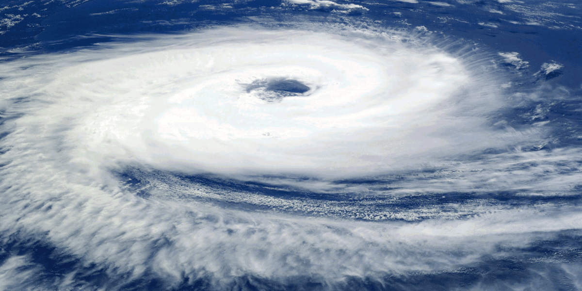
Hurricane Nolo brought heavy rain, flooding, strong winds, and dangerous surf to Hawaii as the powerful storm passed south of the islands.
Heavy rain swept across parts of Hawaii on Saturday, September 26, as Hurricane Nolo moved near the island chain, creating dangerous flooding, strong winds, and hazardous surf. On the Big Island, residents faced a day of rapidly changing conditions as rain bands associated with the hurricane moved across communities. Although the center of Nolo remained offshore, the storm demonstrated how a hurricane does not need to make landfall to create significant hazards across a wide area.
The National Weather Service and National Hurricane Center closely monitored Nolo throughout Saturday. At 5 a.m. Hawaii Standard Time, the hurricane was about 145 miles south of South Point on the Big Island, with maximum sustained winds of 105 mph. At that point, the storm was nearly stationary. Forecasters warned that additional heavy rainfall, gusty winds, and large waves would continue to affect portions of the Hawaiian Islands.
Hurricane Nolo Brings Multiple Hazards To Hawaii
Nolo posed several threats at the same time. Heavy rainfall increased the possibility of flash flooding, while powerful ocean swells created dangerous conditions along exposed coastlines. Strong winds associated with the storm also raised concerns about falling trees, damaged infrastructure, and power disruptions.
The Big Island faced some of the most immediate effects. A tropical storm warning was in effect for the island during the storm, while officials closely monitored conditions as Nolo moved nearby. Earlier forecasts had also placed parts of the island under a hurricane watch because of uncertainty surrounding the storm's track and intensity.
By late Saturday morning, the hurricane had begun moving westward. Forecasters reported that Nolo was gradually turning away from the Big Island, reducing the likelihood that its strongest winds would directly strike the island. The hurricane watch for parts of the Big Island was canceled, although a tropical storm warning remained in effect.
That change did not mean the threat had disappeared. Rain bands, rough seas, and gusty conditions could still extend far from the center of a tropical cyclone. Officials continued to emphasize the possibility of dangerous conditions even as Nolo's center moved farther from Hawaii.
Flooding Becomes A Major Concern
Heavy rainfall was among the most important hazards associated with Hurricane Nolo. Tropical systems can carry enormous amounts of moisture, and Hawaii's mountainous terrain can intensify rainfall in some locations. When heavy rain falls over steep slopes and low lying areas, water can accumulate quickly and make roads hazardous.
Images from the Big Island showed floodwater affecting parts of the island as Nolo passed to the south. Hawaii Army National Guard personnel assisted residents in areas where rainfall created difficult conditions. The storm's effects highlighted the importance of considering rainfall and flooding separately from a hurricane's maximum wind speed.
Flooding can remain dangerous even when a hurricane's center stays offshore. Roads can become impassable, streams can rise rapidly, and saturated ground can increase the possibility of landslides in vulnerable terrain. For Hawaii, those risks were particularly important because communities are spread across areas with sharply different elevations and exposure to rainfall.
Nolo Slowly Moves Away From The Big Island
By 11 a.m. Saturday, forecasters estimated Nolo's maximum sustained winds at about 90 mph. The storm was moving slowly westward, with its center expected to travel away from the Big Island.
Later Saturday night, the hurricane was approximately 200 miles south southwest of South Point and about 335 miles south of Honolulu. Maximum sustained winds were around 100 mph, according to federal forecasters. Nolo was moving west at approximately 9 mph while gradually strengthening.
The changing forecast illustrated one of the challenges of tropical weather. A storm's strength, speed, and direction can shift over relatively short periods, changing the level of risk for individual communities. Residents therefore depend on repeated forecast updates rather than a single prediction issued hours or days earlier.
Why Hurricane Nolo Matters Nationally
Hurricane Nolo is significant beyond Hawaii because it demonstrates the broad range of severe weather threats that can affect the United States simultaneously. While communities in the Northeast dealt with a major coastal storm during the same weekend, Hawaii faced a powerful tropical system thousands of miles away.
The event also highlights the importance of looking beyond the center line of a hurricane forecast. Tropical cyclones are large weather systems, and their rain bands, winds, and ocean swells can reach communities far from the eye.
For residents and travelers, Hurricane Nolo offers a practical reminder that changing conditions require attention to official forecasts. Local warnings can change as meteorologists receive new satellite information, radar observations, and data collected by hurricane reconnaissance aircraft.
What Americans Can Take Away From Hurricane Nolo
The most important lesson from September 26 is that distance from a hurricane's center does not eliminate risk. Hawaii experienced heavy rainfall, flooding, gusty winds, and dangerous waves even while Nolo's center remained well south of the islands.
As the hurricane moved westward, forecasters continued monitoring its strength and the lingering effects across Hawaii. The storm's path spared the islands from a direct strike on Saturday, but its outer effects were enough to create hazardous conditions.
For communities across the United States, Hurricane Nolo underscores a basic principle of severe weather preparedness: conditions can change quickly, and official warnings provide the clearest picture of local risks. In Hawaii, September 26 became another reminder that rainfall, flooding, wind, and surf can remain serious threats even when the eye of a powerful hurricane stays offshore.

Empire State Review Contributor
This article features branded content from a third party. Opinions in this article do not reflect the opinions and beliefs of Empire State Review.
You May Also Like

Akamai And Anthropic Sign $11.6 Billion Cloud Computing Deal As AI Infrastructure Demand Grows
Akamai And Anthropic Sign $11.6 Billion Cloud Computing Deal As AI Infrastructure Demand Grows
Pilot Rescued After Military Training Jet Crashes Into Pacific Ocean Off California Coast
Pilot Rescued After Military Training Jet Crashes Into Pacific Ocean Off California Coast

Green Bay Packers Rally Past New York Jets In Overtime Thriller At MetLife Stadium
Green Bay Packers Rally Past New York Jets In Overtime Thriller At MetLife Stadium
NASA Expands SpaceX Crew Contract With Three More International Space Station Missions
NASA Expands SpaceX Crew Contract With Three More International Space Station Missions
NASA Reveals McGetchin Crater, A Rare New Scar On The Moon
NASA Reveals McGetchin Crater, A Rare New Scar On The Moon